Dabeeo Eartheye 2.0
-
Payment
T/T , WK
-
MOQ
1 ea
-
Country of sale
Asia, Americas, Middle East
-
PRICE
-
EXW
Depend on quantity
-
ITEM SPECIFICS
-
Brand
Dabeeo Eartheye
-
origin
Republic of Korea
-
Size(Capacity)
n/a (Web aplication)
-
Function
Super-Resolution, Object Detection, Segmentation, 3D Reconstruction, Change Detection
-
Package Includes
AI-powered analysis of multi-source imagery
PRODUCT DESCRIPTION
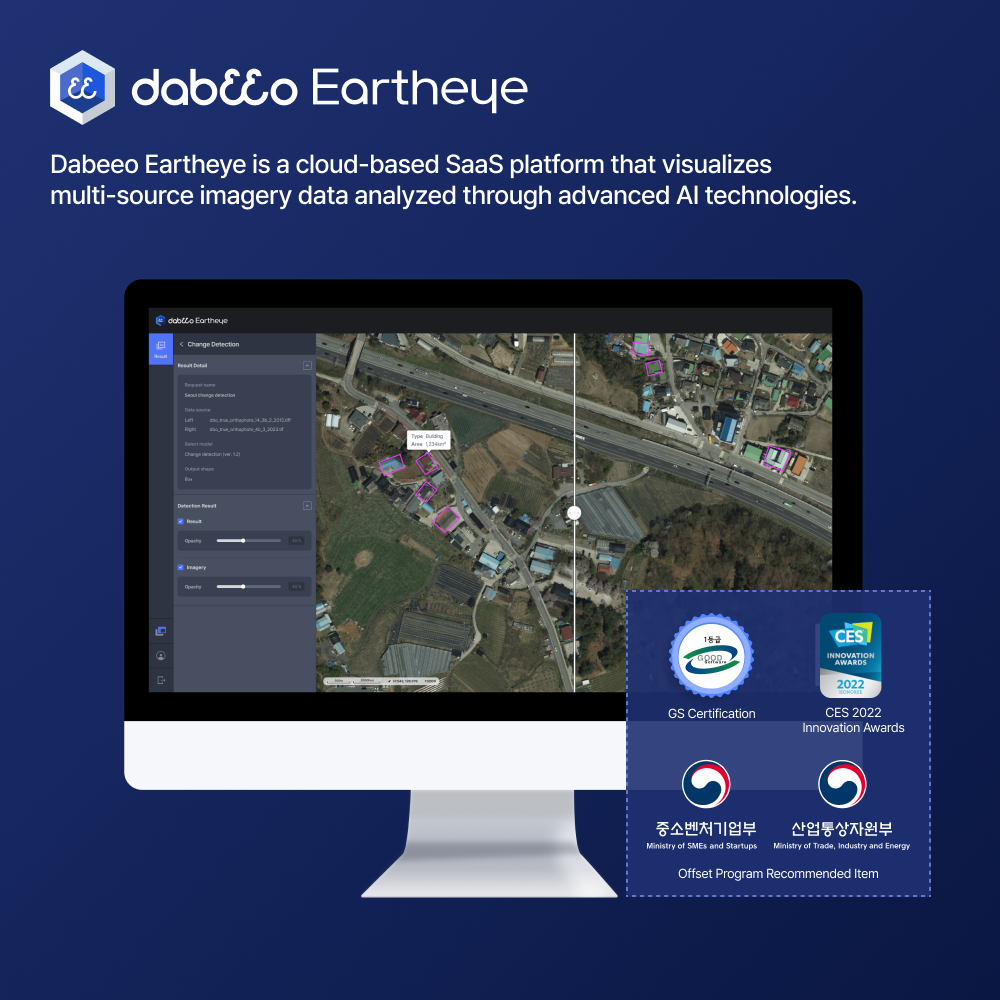
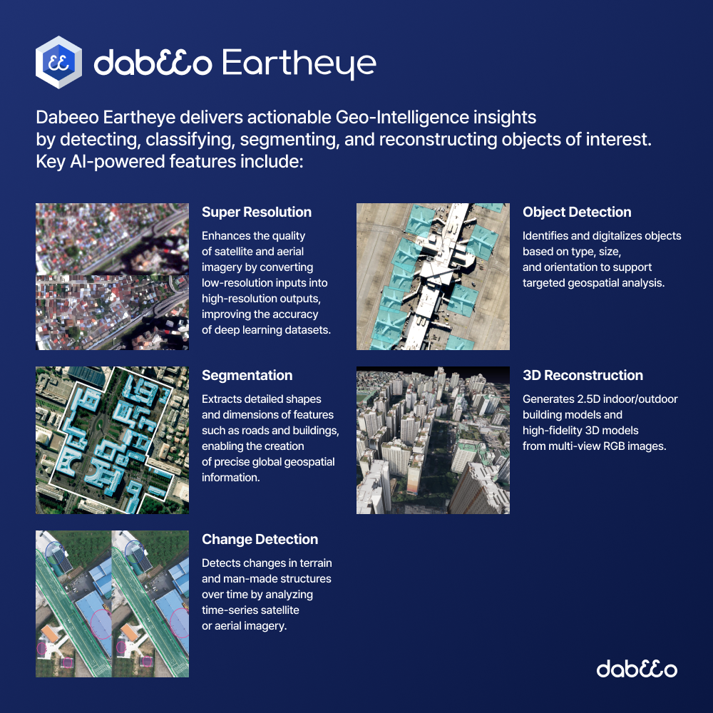
Dabeeo Eartheye is a cloud-based SaaS platform that visualizes multi-source imagery data analyzed through advanced AI technologies.
It delivers actionable Geo-Intelligence insights by detecting, classifying, segmenting, and reconstructing objects of interest.
It delivers actionable Geo-Intelligence insights by detecting, classifying, segmenting, and reconstructing objects of interest.
Key AI-powered features include:
Super Resolution
: Enhances the quality of satellite and aerial imagery by converting low-resolution inputs into high-resolution outputs, improving the accuracy of deep learning datasets.
Object Detection
: Identifies and digitalizes objects based on type, size, and orientation to support targeted geospatial analysis.
: Identifies and digitalizes objects based on type, size, and orientation to support targeted geospatial analysis.
Segmentation
: Extracts detailed shapes and dimensions of features such as roads and buildings, enabling the creation of precise global geospatial information.
: Extracts detailed shapes and dimensions of features such as roads and buildings, enabling the creation of precise global geospatial information.
3D Reconstruction
: Generates 2.5D indoor/outdoor building models and high-fidelity 3D models from multi-view RGB images.
: Generates 2.5D indoor/outdoor building models and high-fidelity 3D models from multi-view RGB images.
Change Detection
: Detects changes in terrain and man-made structures over time by analyzing time-series satellite or aerial imagery.
: Detects changes in terrain and man-made structures over time by analyzing time-series satellite or aerial imagery.
Dabeeo Eartheye has received multiple accolades, including the Grand Prize at the 2nd AI Reliability and Quality Awards from the Ministry of Science and ICT (MSIT), a CES 2022 Innovation Award, and GS Certification from the Korea Testing Laboratory (KTL). It was also selected as one of the Recommended Items for Offset Program by the Ministry of SMEs and Startups and the Ministry of Trade, Industry and Energy.
R&D CERTIFICATE
-
- Certificate of Software Quality
- TTA
- 2024.12.23
- 인증서보기
PAYMENTS DETAILS
This supplier supports payments for offline orders
- WK
- Telegraphic Transfer : T/T
- Name : Joo Huem Park
SHIPPING
Shipping from :
Republic of Korea
- 144 Mapo-daero, Mapo-gu, Seoul (04212)
Dabeeo
The person in charge
JU HUM PARKAddress
144 Mapo-daero, Mapo-gu, Seoul (04212)
QR
Dabeeo
Introduction
Dabeeo provides earth analysis information through AI-based Digital Transformation Technology. Dabeeo’s five core technologies (Super Resolution, Object Detection, Segmentation, 3D Reconstruction, Change Detection) are optimized for the analysis of large geospaces and the extraction of data from targeted areas. With the goal of enabling global-scale digital transformation, Dabeeo delivers digital geospatial information and applied services while continuously developing AI technologies for spatial data generation and analysis.
-
- Business Type :
- Knowledge Service
-
- Main Product :
-
- Established :
- 2012-02-28
-
- Total Annual Revenue :
- 3~4 billion (KRW)
-
- Total Employees :
- 51~100 people
R&D CERTIFICATE
-
- Certificate of Software Quality
- TTA
- 2024.12.23
- 인증서보기
Please suggest a variety of your ideas such as design, impact, enhancements, etc
Captcha Required
Please enter the text on the left image to prevent automatic input.
0 / 4000
질문이 없습니다.
CUSTOMER REVIEWS (0)

TRADE EXPERIENCE
-
- Total revenue
- 3~4 billion (KRW)
-
- Total export revenue (previous year in USD)
- 240,000
-
- Industry experience(years)
- 13
-
- Number of foreign trade employees
- 51~100 people
COMPARISON TO SIMILAR ITEMS more
- No Items
- supplier level
- MEMBER
- Dabeeo Seller's Store
- Seller's Store url
- Response Level
★ ★ ★ ★ ★

- Supplier Level
★ ★ ★ ★ ★
- Transaction Level
★ ★ ★ ★ ★
SUPPLIER BEST
- No Items